Wednesday, 13 July 2011

Hurricanes part 2 - Hurricane Katrina

Hurricane Katrina

First exercise will be to look at the below photos and tell me your first thoughts when you look at the photos. This is to get imagination going and get them thinking in line with Hurricanes 


To recap the last post, Hurricanes are an advanced form of tropical cyclones. They require ocean temperatures over 80 degrees Fahrenheit and moist coverging winds to form so mainly occur in tropical regions.

The above conditions were in place on the 23rd August 2005 when Hurricane Katrina formed over the Bahamas. Its path crossed Florida as a category 1 Hurricane reaching category 3 by the time it reached Louisiana with confirmed deaths of 1,836 people and causing damage estimated at $81 billion.

The video in the BBC link explains the path Katrina took and gives some idea of the strength of this Hurricane:


Hurricane Katrina was one of the five deadliest Hurricanes in the history of the USA being the 6th strongest ever recorded in the Atlantic Ocean.

The video below is just a small example of the strength of Katrina:


So we know the causes of the Hurricanes but what makes them so devastating and what are the common consequences of a Hurricane:

1) Rain- Hurricanes bring with them huge amounts of rain with the majority of the rain falling within a very short space of time which can lead to expansive flooding

2) Winds - Deemed as one of the most devastating aspects of the Hurricanes are the high sustained winds. These cause extensive damage to buildings and homes and can cause storm surges

3) Storm surges - The occur when the hurricane causes a build up of water. When this conincides with high tide this can lead to flooding

All the above are not only dependent on the strength of the hurricane but how it collides with the land. Katrina was particularly devastating as it collided directly with the coast of Louisiana, Mississippi and Alabama with winds of 175mph.


Moving forward?

Below are some ways that America have tried to move forward and repair the extensive damage still there today:

- Repairing damaged Levees in New Orleans to try and protect against any future flooding. This was one of the reasons for the very large death toll
-Rebulding of over a hundred thousand homes lost in the disaster to rehome the many families still in temporary accomodation 6 years on 
-Continual effort to improve tracking and prediction technology available


In summary, Hurricanes can be devastating natural disasters if the right conditions are in place and the location of where the Hurricane occurs collides with human life. As humans continue to battle against nature it only takes one guess to see who came out on top in 2005.


Example classroom exercises:

Tracking a hurricane- I have found a document on the TES website which has a really interactive activity involving tracking past Hurricanes on google earth. This could be expanded up to a full project looking at the causes and consequences of a particular disaster

True/False- Also found a quick summary quiz which has some quick statements about Hurricanes and its purely a game of whether they are true and false and would be good as an end to the whole topic


Tuesday, 12 July 2011

Hurricanes - What are they and how do they form?

What are Hurricanes?


"A tropical cyclone is a storm system chracterized by a large low pressure centre which causes strong winds and heavy rain".

Tropical cyclones are known as different names depending on their location and strength. Tropical Cyclones are generally classed as Hurricanes when the storm has winds over 74mph.

http://www.youtube.com/watch?v=4f45jA5UxB0

The video above is a short summary of how Hurricanes form so lets summarize the key points below:

The requirements for a Hurricane:

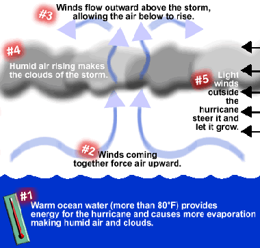
1) Water temperatures of at least 80 degrees Fahrenheit - warm tropical regions
2) Moist air and converging equatorial winds

The majority of Hurricanes form in tropical regions due to the two requirements above. They generally begin life as thunderstorms and as they move over warm tropical ocean waters they pick up speed and power.  Wind speed is gained as cooler air rushes underneath the warm rising air increasing and as this wind is subject to the coriolis effect it starts spinning. Incoming winds increase the power of the Hurricane and direct its course.


Hurricane classification:

Just like most other natural disasters Hurricanes have a classification depending on wind speed and the height of the storm surge. The categories also include levels of damage that are likely to be experienced for a hurricane of that intensity 


Saffir-Simpson Hurricane Scale

So in this post we have covered what Hurricanes are, how they form and on what system they are classified on. Part 2 will be a case study as this was always a big part of my Geography learning and i think its important to be able to apply any learning into real life situations.

The post will cover where and when Hurricanes occur and look in particular at the causes and consequences of Hurricane Katrina.

Some Hurricane facts to end on....

- Australians call hurricanes, willy-willies.
- Every second, a large hurricane releases the energy of 10 atomic bombs (If my sources are correct!)
- Hurricanes didn't start having boys' names until 1979. The first name being Hurricane Bob


Monday, 4 July 2011

The Hydrological Cycle

What is the Hydrological cycle (Water cycle)?

The cycle of water travelling from one reservoir to another by certain physical processes during which the water changes its state.


File:Water cycle.png


There are four main processes in the cycle:

1) Evaporation - A water molecule in the ocean is heated by the sun and is evaporated into vapour in the atmosphere
2) Condensation - Once the molecule is in the atmosphere it is cooled to form into clouds.
3) Precipitation - The winds then move the clouds around the atmosphere. When the clouds are too heavy precipitation occurs
4) Run-off - When water molecules fall onto the land the water will run-off either into ground water or straight back into the ocean

Additional to the above different processes may be involved depending on the surface of the land the water molecule may fall upon e.g Canopy interception and snowmelt

Main facts to remember:

-The water cycle is a continuous closed loop system
-Water is held in 3 states; vapour, gas and solid (Ice)
-Majority of water held in oceans

Bullet points always work well for me as it offers a strong summary and easier to remember. When revising i always used them as triggers to remember each point in more detail

I like the website below which explains the water cycle using animation
This website has 3 levels of understanding building on the basics by including resevoirs and ending on residence times.

http://www.planetguide.net/book/chapter_2/water_cycle.html

Sunday, 5 June 2011

Introduction - Topic and Objectives

First things first for this project was to identify a subject area within Geography i would deem as my weakest. Although much of my Geography degree was based around physical concepts and in theory should be my stronger side i have settled on "Weather and Climate" as this was entirely neglected by me at University. The main reason for this being the heavy physics based concepts associated with weather patterns and systems.

Next step was to break down this large area into smaller bite size chunks. The subject audit was a good place to start looking for this and gave me some idea of how to approach learning more about it. I have also been brainstorming some ideas of how best to incorporate resources used in this blog into the classroom and making them accesible to students.

I wanted to have one solid theme flowing through this whole blog so it would be easy to follow and hopefully give it good structure. As much of my time studying Geography has been focussed on linking concepts with case studies i thought this would be a good place to start. My idea was to follow one part of the UK for a whole week using weather forecasts from the MET office. Then take each days forecast and explain the reasons for the weather by explaining the science behind it.

I do like this idea  however i do think im restricting myself by only using the UK so im going to try a round the world style forecast. Im going to pick different countries in different continents, find the weather forecasts for a particular day and explain the phenomena using geographical concepts. I think students would be able to do this for themselves picking parts of the world that appeals to them and really get stuck in and enjoy looking at weather outside of the UK

Although this will form a large part of the blog i do want to explore other ways of creating discussion and explanations so will hopefully build on this idea over the next few months.

Over the next few days im going to tackle what i think is a good place to start, the hydrological cycle. For this i might not start my "round the world" trip yet but we shall see where the wind blows me!

Coming up....