This post I am going to define both air masses and fronts, look into the classification and definitions of both. Following on from this I am going to do a case study of the UK weather system and what air masses affects Great Britain.
An Air mass is a large body of air defined by its properties of temperature, humidity and lapse rate. These are largely homogeneous over an area several hundred kilometres across. The nature of air masses is determined by three factors: the source region, the age and the modifications that may occur as they move away from their source region across the earth's surface. The nature of air masses change as they adopt the characteristics of the surface below
What are the classifications?
Air masses are classified primarily on the region the mass originated from and whether they originated over land or sea which demonstrates moisture content. They can be additionally categorised by the stability of the atmosphere below the air mass
Below are the common letters used to classify air masses:
Below are the common letters used to classify air masses:
Source region
Arctic- A
Polar – P
Tropical Air – T
Nature of the surface
Continental - c
Maritime – m
Stability of the Atmosphere
Air mass colder - k
Air mass warmer - w
Some common examples of typical wind patterns include:
- Winds over warm land are called Tropical Continental - Tc
- Winds over warm sea are called Tropical Maritime - Tm
- Winds over cold land are called Polar Continental - Pc
- Winds over cold sea are called Arctic Maritime - Pm or Am
Warm fronts – Transition from cold air to warm air
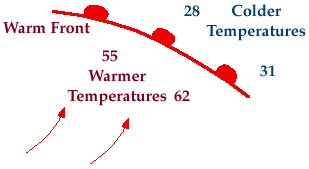
A warm front is the transitional zone where a warm air mass is replacing a cold one. Warm fronts generally move from Southwest to Northeast and the air behind a warm front is warmer and moister than the air ahead of it. When a warm front passes through, the air becomes noticeably warmer and more humid than it was before.
Common characteristics include:
- Noticeable change in temperature in front of and behind a warm front
- Change in wind direction, most commonly winds ahead of the front are typically from the east, but once the front passes through, winds usually shift around to the south-southwest
- Change in relative humidity as the air mass behind a warm front is commonly more moist that the air mass in front.
- Clouds and precipitation usually develop along and ahead of the warm front as warm moist air rides up and over the colder air ahead of it.
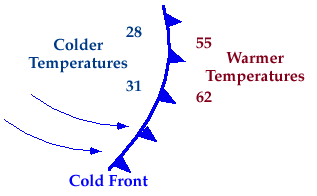
Cold front - Transition from warm air to cold air
A cold front is defined as the transition zone where a cold air mass is replacing a warmer air mass. Cold fronts generally move from Northwest to Southeast. The air behind a cold front is noticeably colder and drier than the air ahead of it.
Common characteristics include:
- Large change in temperature in front of and behind the front with warmer temperatures ahead.
- Change in wind direction is commonly observed, winds ahead of the front are typically out of the South-Southwest, but once the front passes through, winds usually shift around to the West-Northwest.
- Change in relative humidity with the air mass ahead of a cold front typically more moist than the air mass behind it.
- Clouds and precipitation form along and ahead of the cold front as the colder air mass lifts the warm moist air ahead of it.
Occluded front
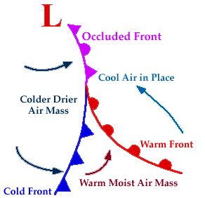
A developing cyclone typically has a preceding warm front and a faster moving cold front. North of the warm front is a mass of cooler air that was in place before the storm even entered the region. As the storm intensifies, the cold front rotates around the storm and catches the warm front. This forms an occluded front, which is the boundary that separates the new cold air mass (to the west) from the older cool air mass already in place north of the warm front. Occluded fronts can occur as warm or cold occluded fronts and have similar characteristics to that of normal warm and cold fronts.
I have found this brilliant link on the TES site which is an interactive session discussing depressions, fronts and in particular the weather affecting Britain.
http://www.ngfl-cymru.org.uk/eng/vtc_-_ks4_-_geography_-_weather_and_climate_-_a_depression_and_its_associated_fronts
Next post im going to look into the weather symbols for fronts and other weather conditions then focus on depressions which are weather systems normally caused by cold fronts. Finally im going to end this section on a case study of the UK weather using all the information i have learnt from the two posts before hand.
No comments:
Post a Comment