Monday, 5 September 2011

Global Circulation- Polar Cell, Ferrel Cell and the associated wind patterns

Following on from the last post which I discussed the Hadley cell and global circulation within this post im going to touch upon the other two less well known cells the Polar cell and the Ferrell otherwise known as the Mid-latitude cell and also discuss the major wind patterns that exist on earth.

So how do we end up with such stunning scenery as this…


The Polar cell

This cell occurs at 60 degrees north and south. The air has been warmed up and rises upwards, creating a zone of low pressure. Though cool and dry relative to equatorial air, air masses are still sufficiently warm and moist to undergo convection. When the air reaches the polar areas, it has cooled considerably, and descends as a cold, dry high pressure area, moving away from the pole along the surface.The Hadley cell and the Polar cell are similar in that they exist as a direct consequence of surface temperatures. The outflow from the cell creates Rossby Waves, these are ultra-long waves which determine the path of the Jet Stream. By acting as a heat sink, the Polar cell also balances the Hadley cell in the Earth’s energy equation.

I think its worth adding in the diagram of the global circulation in just to recap...


The Ferrel cell 

The Ferrel cell occurs between 30 and 60 degrees north and south. The Ferrel cell is dependent for its existence upon the Hadley cell and the Polar cell. It comes about as a result of the the high and low pressure areas of the mid-latitudes. For this reason it is sometimes known as the "zone of mixing." In this cell at higher levels the wind blows equatorward and in a westerly direction and polewards and in an easterly direction on the surface. 

So that covers the three cell model for earths global circulation. Although it can be broken down into the three separate cells the majority of the time they can overlap and are certain wind patterns can override the common characteristics of the cells. 

If we move from the equator towards the poles we experience a number of different wind patterns. There are three main wind belts which occur as the coriolis force cause the flow to be deflected off the circulation cells. 


1) Trade winds (Easterlies): These are mainly associated with the Hadley cell. This wind pattern blows mainly North East in the Northern Hemisphere and South East in the Southern Hemisphere. The Trade winds occur across the equatorial region known as the Inter Tropical Convergence Zone (ITCZ) and when the two Hemisphere winds meet a low pressure area of calm winds form called Doldrums. The trade winds generally cause Cumulus clouds to form and when weaker during the Arctic Oscillation cause more rainfall across North America.


2) The Prevailing Westerlies: These are mainly associated with the Ferrel cell. They typically blow from the South West in the Northern Hemisphere and from the North west in the Southern Hemisphere. The Westerlies are strongest when the pressure at the poles are low and weakest when the pressure at the poles is high. They strongly influence the movement of the oceans playing an important role in moving warm waters and winds towards the western coastal regions of continents. When the Westerlies meet the trade winds the Horse latitudes occur which are characterized mainly by light, calm winds.


3) The Polar Easterlies: These are mainly associated with the polar cell. The dry cold prevailing winds blow from the north down to the Westerlies. The southerly flow of air towards the equator is because of the cold air subsiding at the poles. The polar easterlies are generally irregular and weak unlike the other wind patterns. When the Polar Easterlies converge with the westerlies the polar front occurs with similar weather conditions.


Finally as we have discussed the three main circulation cells, the three main wind belts and there are also some main pressure belts across earth:

They are:

1) Equatorial low – A region of low pressure associated with the rising air in the ITCZ. Warm air heated at the equator rises up into the atmosphere leaving a low pressure area underneath. As the air rises, clouds and rain form.
2) Subtropical high – A region of high pressure associated with sinking air in the horse latitudes. Air cools and descends in the subtropics creating areas of high pressure with associated clear skies and low rainfall. The descending air is warm and dry and deserts form in these regions.
3) Subpolar low – A region of low pressure associated with the polar front.
4) Polar high – A high pressure region associated with the cold, dense air of the polar regions.

Classroom tasks:

One task could be for students to draw there own global circulation model drawing on arrows representing wind patterns and include both the pressure bands and the cells. This also could be a good chance for students to present. They could pick one of the cells explaining in detail the patterns of wind and pressure associated with that cell 

Global Atmospheric Circulation- An Introduction

Atmospheric circulation is the large-scale movement of air by which heat is distributed on the surface of the Earth. Solar energy powers the atmospheric system and the energy circulations within it. The amount of solar energy (heat budget) received varies with latitude.  The tropics have an energy surplus as they gain more from insolation than is lost by radiation.  But the higher temperate and polar latitudes have an energy deficiency losing more by radiation than is gained by insolation

This disparity in the earth’s heat budget is counteracted by the ocean currents which accounts for 40% of the redistribution and atmospheric circulation accounting for 60% respectively.

This is achieved through three main convection cells:

1) Hadley Cell (Tropical Cell)
 
2) Ferrel Cell (Mid-latitude Cell)
3) Polar Cell

While the Hadley, Ferrel, and Polar cells are major players in global heat transport, they do not act alone. Disparities in temperature also drive a set of longitudinal circulation cells, and the overall atmospheric motion is known as the zonal overturning circulation.
 
As the Coriolis force runs across the 3 convection cells it causes the deflection of the wind creating some main patterns:

1) Easterlies
2) Doldrums
3) Westerlies
4) Horse Latitudes
5) Polar Easterlies
6) Polar front

This post is going to focus on the Hadley cell as this is said to have most impact on the atmospheric circulation.

The Hadley cell is a three dimensional atmospheric circulation cell located at roughly 0 to 30° North and South of the equator. Low latitude air moves towards the Equator and heats up.  As it heats it rises vertically and moves polewards in the upper atmosphere. This forms a convection cell that dominates tropical and sub-tropical climates.


As mentioned previously in this post near the poles, heat is lost to space by radiation exceeds the heat gained from sunlight, so air near the poles is losing heat. Conversely, heat gained from sunlight near the equator exceeds heat losses, so air near the equator is gaining heat. Air rises near the equator, flows north and south away from the equator at high altitudes, sinks near the poles, and flows back along the surface from both poles to the equator.

The combination of these two processes sets up a general circulation pattern: air rises near the equator, flows north and south away from the equator at high altitudes, sinks near the poles, and flows back along the surface from both poles to the equator. The video above just demonstrates the Hadley cell circulation in more detail and summaries all of the above.

http://www.youtube.com/watch?v=DHrapzHPCSA


Classroom task

I would like to do a summary of the Hadley cell circulation. I would like the students to chose how they would do this but the requirements would include at least 6 bullet points of how the circulation works. Other tasks could include true/false statements about the Hadley cell also getting in the diagram and filling in the stages of the circulation cell.

Next post will be explaining the other two cells; Polar and Ferrel in more detail and also beginning to explain the major wind patterns.

Hurricane Irene August 2011

Hurricane Irene

Although I have already covered Hurricanes I thought it was only appropriate to do a quick blog post on the recent Hurricane to hit the shores of the Carribean and the southern states of the USA. Despite it being much less destructive than anticipated, the scale of damage caused by Hurricane Irene was still substantial.

Just a short video footage of the hurricane...

http://www.youtube.com/watch?v=CdW8vdUm70M&feature=related

Characteristics of Irene:
  • The first notable Hurricane of the Atlantic season
  • Formed on 20th August and raged across the Caribbean, USA and up through Canada until dissipating on the 29th August
  • Highest winds recorded were 120mph and at its largest had a diameter of over    500  miles!
  • At its peak Irene was a Category 3 Hurricane


Below is an image of the path Hurricane Irene took over the 9 days it was present over the Atlantic area. The image also shows when it was at its most dangerous using the Saffir- Simpson scale


3 p’s
Something I still remember from studying weather is the 3 p’s associated with natural disasters. They can vary by definition but im choosing Prediction, Prevention and Preparation. This is something that this article will focus on and will show how implementing the 3 p’s successfully can drastically reduce damage.


Prediction

The majority of this is done by the monitoring of Satellites and local weather conditions to determine the path the Hurricane is likely to take. By predicting this prevention methods can be put in place. Weather stations are constantly monitoring weather conditions so can issue warnings in advance to whether a tropical cyclone is likely to be upgraded to a Hurricane

Prevention

This particular category is hard to apply to Hurricanes as in the simplest of terms they are impossible to prevent. However, prevention can be applied in other ways including prevention of damage to housing, infrastructures and loss of human life. This is where Preparation is key as by putting solid methods in place prior to the Hurricane reaching shore the damage can be drastically reduced.


Preparation

Below are just some of the methods the USA had in place prior to the Hurricane reaching major cities such as New York:

  • Severe Weather warnings in place across 8 states
  • 2 million people ordered to evacuate including 300,000 people living in low lying areas of New York
  • 90 shelters set up in New York for over 70,000 people
  • Entire shutdown of New Yorks transit system including the subway, rail travel and bus travel
  • 200 trucks of emergency supplies and 100,000 national guards on stand by 

What was the damage from the Hurricane? 
  • 55 fatalaties caused by Hurricane Irene
  • Total damage caused is approximately $10 Billion
  • Extensive flooding across New york and Vermont


Conclusion

Although I haven’t covered any new concepts in this post it is always interesting to see how natural occurring events such as Hurricanes affect humans and how despite our technological advances we can’t overcome human nature. Despite this it is clear to see how our technology has allowed huge advances in predicting paths hurricanes may take and through this enabling preparations to be put in place such as mass evacuations and protections of infrastructure.

Finally, with the Atlantic Hurricane season only just beginning i think we can be fairly certain that more damage from Hurricanes will be felt over the coming months

Have a quick look at the below article which gives an interesting read....

Friday, 26 August 2011

Measuring and Analysis of Climate- Some examples

Weather Balloons:
Weather balloons were first used over a century ago and were used to establish the presence of the stratosphere and tropopause. This equipment consists of a latex balloon, a parachute and a radiosonde which hangs below.

Similarly to the weather station, the radiosonde measures temperature with a thermometer, humidity with hygrometer and air pressure with a barometer, taking continuous measurements as the balloon rises. The equipment includes a tracking device which monitors the movement and converts wind speed and wind direction. An example of a weather balloon which climbed to 93,000 feet can be viewed here;

http://www.youtube.com/watch?v=dRZJdJ-HZY8.  

Satellites:
Infra-red satellite images play a large part in determining global weather patterns and revolutionized meteorology (the study of weather) in 1960 when the first image returned to earth. The image below shows infra-red radiation over the UK. This is emitted by both clouds and the earth’s surface and gives an accurate reading of temperature. This is found using a grey scale with lighter areas of cloud indicating where the cloud tops are cooler and therefore where weather features like fronts and shower clouds are.

This has come on a long way since the first satellite image, taken in 1960. This was the beginning of the highly accurate reports produced in the modern day.

Analyses:
The data provided by weather stations, buoys, balloons and satellite imagery are all compiled into highly complex mathematical computer models. The outputs of these are the weather forecasts which are produced and shown in the media every day.
A weather forecast is produced by translating physical laws which govern weather into mathematical equations. These equations form a 3D ‘dynamical model’, an example of which can be seen below (depicting Hurricane Floyd). The information which can be input into these equations is found using the measurement methods mentioned before.

These computer models forecast how the atmosphere is most likely to react over a period of time but are constrained by technology. For example certain variables may not be considered if they aren’t input. The forecast at this stage then needs to be translated into a more universal forecast using Model Output Statistics (MOS) equations. These are calculations which look at past model outputs and actual weather. By including actual weather this helps to provide a more accurate and localised forecast. A human forecaster will calculate the MOS equations and make a comparison with the computer model. This can then be used to make an accurate expectation of the weather.

Thursday, 25 August 2011

Measuring and Analysis of climate

Moaning about the weather....very British but how easy is it to put together a weather forecast and is it done in modern times as it was done in the past. I have looked into the factors that need to be considered when discussing the climate and some ways climate is measured.
To measure climate accurately 7 factors need to be considered. These are:
·         Temperature and precipitation – varying temperature is arguably the most direct indication of changes within the atmosphere.
·         Pressure – similarly to temperature this is an indication of atmospheric conditions.
·         Biomass – this is analysed by monitoring flora and fauna over longer periods of time and identifying differences in species and mass.
·         Sea level – changes in sea level can indicate variations in ocean salinity, a factor known to both be greatly affected by climate and to greatly affect climate.
·         Solar activity – influences climate through varying solar radiation.
·         Volcanic eruptions – alter climate patterns locally by aerosol emissions.
·         Chemical composition – research indicates a strong correlation between certain gasses (e.g. CO2 and CH4) and temperature.
In the past measuring climate focused on air pressure, temperature, precipitation. This relied on comparatively simple technology such as the pressure gauge, thermometer or rain gauge. In the modern day, measurement and analyses of weather is primarily carried out using a combination of weather balloons, satellites and local weather stations.
Local weather stations:
Weather stations are able to measure several of the variables mentioned above using incredibly precise equipment. A weather station will typically be located in open areas where the human impact on surrounding environment is limited. Weather stations aren’t limited to set points on land but also come in the form of ships and buoys which can monitor conditions at sea.
Weather stations tend to have vast amounts of equipment to monitor wind speed, humidity and temperature which are measured with varying instruments.
Wind speed: most weather stations will be equipped with a highly accurate weather vane to indicate wind directions as well as an anemometer.  The anemometer indicates wind speed and is composed of small cups which are caught in the wind causing the device to spin at a speed. This spinning is then translated into a wind speed, commonly expressed in Mph.
Humidity: this is measured using a hygrometer. Arguably the most accurate type is the chilled mirror hygrometer which measures the temperature of a mirror at the point that a drop of moisture begins to condense. This gives name to the dew point.
Temperature:  the majority of weather stations are equipped with a ‘Stevenson screen’ which ensures the measurement of temperature (via a thermometer installed internally) isn’t affected by solar irradiation.

 The slats on the side allow air to circulate and ensure an accurate temperature reading. Two thermometers are placed inside, one of which is constantly wet. This can be used to indicate evaporation and (therefore humidity) in a similar fashion to the hygrometer.   
Next post- I will be adding some more examples of measuring climate and providing some form of analysis on the different methods chosen to monitor climate

Tuesday, 16 August 2011

Atmospheric Lapse Rates

What does it mean?

The atmospheric lapse rate describes the reduction, or lapse of air temperature that takes place with increasing altitude. Lapse rates related to changes in altitude can also be developed for other properties of the atmosphere.
There are three types of lapse rates, Dry Adiabatic, Saturated Adiabatic and Environmental Lapse rates.

If a material changes its physical state (that is, if its pressure, volume, or temperature change) without any heat being either added to it or withdrawn from it, the change is said to be adiabatic. So, an Environmental Lapse rates refers to a change in a physical state with heat added.

What affect do Lapse rates have on the environment?

The average atmospheric lapse rate results in a temperature decrease of 3.5°F (1.94°C) per 1,000 feet (304 m) of altitude.

There are two types of lapse rates, Dry Adiabatic and Saturated Adiabatic both of which have varying temperature changes, so what are they?

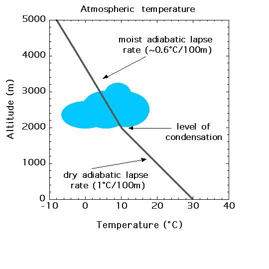
Dry Adiabatic - A dry, not saturated parcel of air, has a dry adiabatic lapse rate of 1°C/100m
Saturated Adiabatic - This saturated parcel of air has a saturated adiabatic lapse rate of 0.6°C/100 m


From the atmospheric lapse rates you can tell whether the atmosphere is stable or unstable. This can be seen when the actual lapse rate is either greater or less than the dry adiabatic lapse rate. This variation from the dry adiabatic lapse rate is what determines whether the air is stable or unstable.

The vertical air temperature distribution in the atmosphere is highly variable. For dry air it ranges as follows:
  1. Very stable : Temperature increases with increase in altitude. This is a "plus" temperature lapse rate, or an inversion.
  2. Stable : Temperature lapse rate is less than the dry adiabatic rate, but temperature decreases with altitude increase.
  3. Neutral : Temperature lapse rate is the same as the dry adiabatic rate of 5.5 degrees Fahrenheit per 1000 feet increase.
  4. Unstable : Temperature lapse rate is greater than the dry adiabatic rate. It may be 6 degrees Fahrenheit or more.
  5. Very unstable : Temperature lapse rate is much greater than the dry adiabatic rate, and is called super-adiabatic.

Classroom tasks:

Some tasks could include picking key words and asking for explanations. I would want students to know the main difference between lapse rates and also explain each condition for the stability of the atmosphere.

Although this isnt the best example, there could be a graph plotting exercise showing lapse rates and temperatures:

http://www.mhartman-wx.com/fcst_tools/lapse_rates.html

Tuesday, 2 August 2011

Human Impact- Case Study 1 - The Great Pacific Garbage Patch

Each year, three times as much rubbish is dumped into the world's oceans as the weight of fish caught.

So what is the Great Pacific Garbage Patch...


It is a gyre of Marine litter twice the size of France situated off the coast of California that is estimated to contain 100 million tonnes of waste, predominantly plastic. In 2009 the ocean was said to have 46,000 pieces of plastic per squre kilometre of ocean which out weighs the amount of Plankton by the ratio 6:1.The great Pacific patch is the largest landfill site in the world although there are other Garbage patches, most notably in the North Atlantic and the Indian Ocean.

How did it get there?

The plastic has travelled far and wide down streams and rivers finally entering the ocean where the waste accumuates into one large landfill site. Additional to land pollution of plastic, other sources include commercial fishing, recreational boaters, merchant military vessells and offshore oil and gas platforms.


What are the main affects on the environment?

The largest effect of the garbage patches in the ocean is to the marine life. Although it is widely accepted that plastic itself is not toxic, it attracts and allows other harmful chemicals to accumulate such as PCB and DDT. These chemicals in high levels are dangerous to most species of animals.

"Worldwide, according to the United Nations Environment Programme, plastic is killing a million seabirds a year, and 100,000 marine mammals and turtles."


Although chemical pollutants are dangerous the main cause of death is entanglement in the plastic waste or swallowing and thus choking on plastic particles. The larger pieces of plastic can cause the entanglement however it is the smaller pieces which can be swallowed. Plastic is not biodegradable however, it can be photodegraded. This breaks down larger pieces of plastic in smaller particles which then remain in the ocean.

What can be done to help?

There are many ongoing relief efforts which are aimed at recovering large amounts of plastic from the oceans. There are also quite a few charities which are commited to helping clean up the garbage patches.

One charity which appears quite influential from the research i have carried out is http://www.5gyres.org/
The main mission of the charity is outlined below:

"To conduct research and communicate about the global impact of plastic pollution in the world’s oceans and employ strategies to eliminate the accumulation of plastic pollution in the 5 subtropical gyres."

This is just a small example of how humans can impact the environment on a grand scale with the consequences of human actions irrevocable.  Although this does stray away from the topic of weather slightly i do think its important to look at this topic in broad terms.

Classroom tasks
This is a difficult issue to tackle with the human race so accustomed to using plastic as the predominant packaging material. One task could students working together in groups to think of ways the "garbage patch" phenomena can be avoided in the future and also how best to tackle the current issue of waste in the oceans.

Another question to pose could be whether they think its acceptable to use to oceans in such a way. This could be a good linking question as can be made relevent to alot of geographical concepts such as space, place and population