Thursday 15 September 2011

Resources....

This is one of my final posts so thought i should include some of the pages that i have used within my blogs and also some websites with some brilliant ideas for lesson planning


Free to register and well worth it!
It’s great to search for information and give some ideas of how to incorporate some concepts into lessons


I signed up a couple of months back and have received a few emails through with very helpful links to pages. 
The one below is brilliant; must have teacher tool kit! It has all sorts of lesson starters, ideas for activities etc


This website has some interesting case studies and ideas for activities within lessons


Quite an obvious resource but one not to be overlooked, lots of articles on all aspects of the environment and i found it extremely useful for weather and climate topics- also has GCSE bitesize revision!


Quite an unsuspecting resource but had a wealth of information with easy to understand explanations and diagrams all about weather and climate


Different year groups and all different topics of geography available here with lots of information and lesson ideas


I used this one quite a lot when i was completing the blog on weather and climate. Has some in depth tutorials that pupils could use themselves with additional information to build on basic knowledge


Loved this website! Found it really interesting and had lots of information about all sorts of topics within geography.


Saturday 10 September 2011

Drought


Droughts are natural events. A drought happens when a period of low rainfall creates a shortage of water for people, the environment, agriculture, or industry. Some droughts are short and intense, for example, a hot, dry summer, while others are long and take some time to develop.


You can see from the map above the countries with the most common occurrences of drought over 30 years from 1974 – 2003. The main pattern is that the large majority of the drought regions lie in the southern hemisphere and in particular the Horn of Africa. In this part of Africa 12 million people are currently at risk of severe famine as 2 years of drought have pushed food prices through the roof. 

The article below has a very clear interactive map to the current humanitarian disaster in the Horn of Africa and has some truly scary statistics;


This post however is going to look into the recent drought currently underway in Texas, USA and the surrounding states. Texas has recorded its hottest summer in US history with many scorching days seeing temperatures over 110 °F. This record breaking summer has had many drastic consequences across the US and fears are that the drought could have global effects. The main cause of this drought is believed to be due to the 6th strongest La Nina year since 1949 causing a shift in the jet stream taking away moisture from the South.

What are the main consequences of this?

- Early estimates for crop and livestock losses are a staggering $5.2 billion, with the figure expected to rise as the drought continues
- Texas has lost a little over half of its cotton crop. As Texas produces 55% of the U.S. crop and two-thirds of America's export market cotton prices are surging due to the shrinking supplies.
-Catastrophic fires have been raging for months now due to the dry land and hot temperatures. The most recent have been classed as “worst fires on record” in Texas.

Bastrop Country fires


The Bastrop county fires began on the 4th September 2011 and continue to rage on. The fire now covers over 20,000 acres and is about 16 miles wide. A perilous mix of hot temperatures, strong winds and a historic drought has caused the Bastrop-area fire, the largest of the nearly 190 wildfires the state forest service says erupted this week, killing four people, destroying more than 1,700 homes and forcing thousands to evacuate.

Friday 9 September 2011

La Nina/ El Nino

Both El Niño and La Niña are driven by water temperature and atmospheric conditions. These two are coupled: the warm oceanic phase, El Niño, accompanies high air surface pressure in the western Pacific, while the cold phase, La Nina, accompanies low air surface pressure in the western Pacific.Mechanisms that cause the oscillation remain under study.

La Nina

During La Niña years, the trade winds are unusually strong due to an enhanced pressure gradient between the eastern and western Pacific. As a result, upwelling is enhanced along the coast of South America, contributing to colder than normal surface waters over the eastern tropical Pacific and warmer than normal surface waters in the western tropical Pacific. This enhances normal levels of fish stocks as the upwelling of deep waters are nutrient rich.


El Nino
The trade winds do not replenish and sometimes even reverse direction to blow from west to east. This causes warm surface waters from the east to move eastward. Beneath the surface, the thermocline along the equator flattens as the warm waters at the surface effectively cap preventing the colder, deeper waters from upwelling. As a result, the large central and eastern Pacific regions warm up into an El Niño with waters warming by 3° to 5°F.


Below i have added a table that i created to summarise the difference between the two climatic conditions:


Below i have listed some websites with more information as i found it quite difficult to explain the two conditions:

This website has quite a lot of information with some interesting diagrams

I have used this website quite a bit during the blog as i always find the explanations interesting and easy to understand

NASA website also has some in depth explanations

Human impact – Case study 2- Are we running out of water?

The Planet Earth has a surface that is dominated by water, approximately 70% so why would be running out?


The problem
Although 70% of Earths surface is water only 2.5% of that is not salt water, and two-thirds of that is locked up in the icecaps and glaciers. Of what is left, about 20% is in remote areas, and much of the rest arrives at the wrong time and place, as monsoons and floods. Humans have available less than 0.08% of all the Earth's water. Yet over the next two decades our use is estimated to increase by about 40%.


This issue has to lead to some new discussions presented within the geography field including the term “peak water”. Ultimately, peak water is not about running out of fresh water, but about reaching physical, economic, and environmental limits on meeting human demands for water and the subsequent decline of water availability and use.


It is estimated that if the world continues at the same growth rate 1.8 billion people will be living with absolute “water scarcity” by 2025, and two thirds of the world population could be subject to “water stress”. These two terms refer to the demands of water exceeding available supplies.


Why has this problem occurred?

This has occurred from a combination of factors but the predominant factor has to be the global population boom over the last few decades. As populations grow, so too, do their demands on water. People must be fed, and agriculture must have water to grow crops and livestock. This puts a demand on naturally available water. Humans — via agriculture, industry and other demands - use about half of the world's renewable and accessible fresh water.


What are the consequences?

  • Lack of sanitation- Something that is already an issue isn't a lack of water, but a lack of clean water: Millions of people die each year from preventable diseases, after drinking water from an unsanitary source, this could be exacerbated
  • Famine- As water stress continues to increase there will be a struggle to continue food production at current rates with agriculture already consuming the majority of fresh water available mainly through irrigation techniques
  • Human conflict- It is known through historical records of past wars that water scarcity is a common cause for conflict. This could be a real issue in the future with an ever increasing global population
  • Drought- Reduced stream flow, river flow and shrinking lakes could lead to droughts. With many aquifers being over-pumped and are not recharging quickly enough this could be an issue.

Is this really occurring?

With many environmental issues springing up each year it is always important to employ speculation when looking at issues such as water stress/scarcity. From looking at many articles discussing water stress it is most definitely and issue and something that should be monitored. It does appear that this is another issue that may not become a real issue to the public until it has a direct impact on their lives

There are some easy quick fix solutions:
  1. Water conservation such as improving irrigation systems to reduce amount of water wasted
  2. Improved Water management including the use of technology for efficiency monitoring
  3. Improved crop knowledge by using less water intensive crops
What about this for a cool alternative.....


http://www.guardian.co.uk/science/2011/aug/30/firing-laser-beams-atmosphere-rain 

Wednesday 7 September 2011

Case Study - UK Weather system

I have looked into air masses, fronts, depressions and also weather forecasting and now its the time to look at how all of the above affects the weather conditions experienced in the UK

Characteristics of the UK climate

The overall climate in England is called temperate maritime. This means that it is mild with temperatures not much lower than 0ºC in winter and not much higher than 32ºC in summer. It also means that it is damp and is subject to frequent changes.

Britain has four distinct seasons of fairly equal length - spring, summer, autumn and winter. In winter it is colder and wetter and the days are shorter than in summer. Along with 4 seasons in the UK there are also regional variations in climate. Generally the South is warmer than the north, the West and North West experience higher levels of precipitation and are also generally windier than the rest of the UK

So what causes the variations in climate?

You can see the image below shows the winds that each part of the UK experience and the general conditions this brings to the UK.


Above is a map showing the predominant air masses. Each of these have typical weather conditions:

Arctic Air (A):
  • Continental arctic (cA): Originating over the Arctic ocean in winter it brings extremely cold temperatures and very little moisture. 
  • Maritime arctic (mA): From the same source region, but less dry and less cold - in a way less extreme.
Polar Air (P):
  • Continental polar (cP): Originating from high latitudes this air mass often brings the cold, dry and clear weather in winter and also dry and warm weather in summer.
  • Maritime polar (mP): Originating as continental polar air over the North America Cool, when heated by the relatively warm water bodies this air mass becomes rather unstable resulting in blustery showers over the sea and windward coasts.
Tropical Air (T):
  • Continental tropical (cT): Originating from the arid and desert regions during summer. The least common air mass to affect the British weather however it can bring record heat to south-east Britain, particulary in late-summer.
  • Maritime tropical (mT).Originating from the Azores this brings mild and damp conditions in winter and warm and muggy conditions during summer. This air mass approaches the British Isles from the west, leading to overcast skies with prolonged rain for the western half of the country.

So we can see that the general climate in the UK and the variations experienced are largely influenced by the various air masses ranging from Arctic Maritime through to Tropical Continental.

Additional to the air masses other factors influence the British weather:

Continentality- This is the tendency of land to experience more thermal variation than water, due to the land's lower specific heat capacity. Continentality affects both temperature and precipitation across the UK

Prevailing wind- Britain's prevailing winds come from a south westerly direction over the Atlantic. The winds are cool in the summer and mild in the winter.

Gulf stream- Ocean currents can have a dramatic effect on a countries climate. In the UK, the Gulf stream has a very large impact on the weather experienced due to our close proximity to the Atlantic ocean.


The Gulf Stream is a warm ocean current in the North Atlantic flowing from the Gulf of Mexico, northeast along the U.S coast, and from there to the British Isles. The Gulf of Mexico has higher air temperatures than Britain as it's closer to the equator. This means that the air coming from the Gulf of Mexico to Britain is also warm. It is believed to warm the UK by 5-8 degrees Celsius.  However, the air is also quite moist as it travels over the Atlantic ocean. This is one reason why Britain often receives wet weather.

Classroom task

The past three posts have all focussed on air masses, fronts and the direct effect of them on UK weather. A nice summary of this would be a weather forecast presentation. It would be a group task to encourage the students to work together. They would pick a part of the UK and make a weather forecast up. It would include weather symbols, fronts and explanations behind all weather including causes for the conditions. There are a lot of resources available on websites for examples of forecasts.

Tuesday 6 September 2011

Weather symbols and depressions

Following on from the last post i thought it would be good to add some information about weather symbols, typical forecasts and how to interpret them to understand weather systems. Additional to this, the post is going to touch upon depressions before leading in to the next post which will discuss The Great British Weather!

So below is an image listing all the relevant weather forecast symbols:


Included in the table above are symbols for fronts which were looked at in the last blog. Additional to this there are symbols for wind, cloud cover and additional conditions such as rain and fog. Although weather forecasts have changed visually over the last 30 years its still important to be able to understand the symbols and be aware of their definition. Below is just an idea of how they would normally be found together:


I have found a blank one of these which could be a quick 5 minute recap at the end of a lesson where students can fill in the blanks about each bit of the diagram

http://ww2010.atmos.uiuc.edu/guides/crclm/act/gifs/wx1.gif

Depressions

Its slightly mismatch to move from weather symbols into depressions but i wanted to add this in before i looked at Great British weather.
So what are they....

Depressions are areas of low atmospheric pressure which create unsettled weather conditions including clouds and rain. This is due to the fact that the air within the depression is rising, causing it to cool and the water vapour within it to condense into clouds. This rising air within a depression causes an area of low pressure at the surface. The deeper the depression the more unsettled the weather. Although conditions like precipitation are common for depressions the conditions are not uniform and can vary through the depression.

The page below has a brilliant explanation of how they form
http://www.bbc.co.uk/schools/gcsebitesize/geography/weather/weathersystemsrev3.shtml


Below is a good activity i have found from the TES website- http://www.tes.co.uk/teaching-resource/Depressions-3009177/

Depressions generally form over the Atlantic and move across to the UK. This weather system is the main influence on the weather experienced in the UK which the next post will be focus on.

Air masses and fronts

This post I am going to define both air masses and fronts, look into the classification and definitions of both. Following on from this I am going to do a case study of the UK weather system and what air masses affects Great Britain.


What is an air mass?

An Air mass is a large body of air defined by its properties of temperature, humidity and lapse rate. These are largely homogeneous over an area several hundred kilometres across. The nature of air masses is determined by three factors: the source region, the age and the modifications that may occur as they move away from their source region across the earth's surface. The nature of air masses change as they adopt the characteristics of the surface below

What are the classifications?

Air masses are classified primarily on the region the mass originated from and whether they originated over land or sea which demonstrates moisture content. They can be additionally categorised by the stability of the atmosphere below the air mass

Below are the common letters used to classify air masses:

Source region 
Arctic- A 
Polar – P 
Tropical Air – T 

Nature of the surface 
Continental - c 
Maritime – m 

Stability of the Atmosphere 
Air mass colder - k 
Air mass warmer - w 

Some common examples of typical wind patterns include:
  • Winds over warm land are called Tropical Continental - Tc
  • Winds over warm sea are called Tropical Maritime - Tm
  • Winds over cold land are called Polar Continental - Pc
  • Winds over cold sea are called Arctic Maritime - Pm or Am

When air masses meet...the boundary where air masses of different densities meet fronts form. Fronts are the dominant cause of meteorological changes and can be classed as warm, cold or occluded.


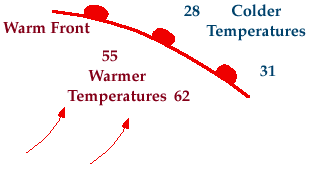
Warm fronts – Transition from cold air to warm air


A warm front is the transitional zone where a warm air mass is replacing a cold one. Warm fronts generally move from Southwest to Northeast and the air behind a warm front is warmer and moister than the air ahead of it. When a warm front passes through, the air becomes noticeably warmer and more humid than it was before.

Common characteristics include:
  1. Noticeable change in temperature in front of and behind a warm front
  2. Change in wind direction, most commonly winds ahead of the front  are typically from the east, but once the front passes through, winds usually shift around to the south-southwest
  3. Change in relative humidity as the air mass behind a warm front is commonly more moist that the air mass in front.
  4. Clouds and precipitation usually develop along and ahead of the warm front as warm moist air rides up and over the colder air ahead of it.


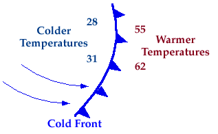
Cold front - Transition from warm air to cold air

A cold front is defined as the transition zone where a cold air mass is replacing a warmer air mass. Cold fronts generally move from Northwest to Southeast. The air behind a cold front is noticeably colder and drier than the air ahead of it.


Common characteristics include:
  1. Large change in temperature in front of and behind the front with warmer temperatures ahead.
  2. Change in wind direction is commonly observed, winds ahead of the front are typically out of the South-Southwest, but once the front passes through, winds usually shift around to the West-Northwest.
  3. Change in relative humidity with the air mass ahead of a cold front typically more moist than the air mass behind it.
  4. Clouds and precipitation form along and ahead of the cold front as the colder air mass lifts the warm moist air ahead of it.

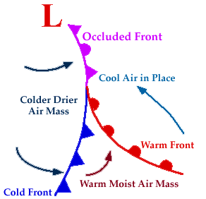
Occluded front


A developing cyclone typically has a preceding warm front and a faster moving cold front. North of the warm front is a mass of cooler air that was in place before the storm even entered the region. As the storm intensifies, the cold front rotates around the storm and catches the warm front. This forms an occluded front, which is the boundary that separates the new cold air mass (to the west) from the older cool air mass already in place north of the warm front. Occluded fronts can occur as warm or cold occluded fronts and have similar characteristics to that of normal warm and cold fronts.

I have found this brilliant link on the TES site which is an interactive session discussing depressions, fronts and in particular the weather affecting Britain.

http://www.ngfl-cymru.org.uk/eng/vtc_-_ks4_-_geography_-_weather_and_climate_-_a_depression_and_its_associated_fronts

Next post im going to look into the weather symbols for fronts and other weather conditions then focus on depressions which are weather systems normally caused by cold fronts. Finally im going to end this section on a case study of the UK weather using all the information i have learnt from the two posts before hand.